Jan 20, 2025
Spatial Layout Characteristics of Northern Wei Luoyang: A Spatial Humanities Analysis of the “Record of the Monasteries of Luoyang”
- Runfeng Sun1,
- Wenjia Liu2
- 1School of architecture, Zhengzhou University;
- 2Architecture School, Zhengzhou University
- Wenjia Liu: Corresponding Author;


Protocol Citation: Runfeng Sun, Wenjia Liu 2025. Spatial Layout Characteristics of Northern Wei Luoyang: A Spatial Humanities Analysis of the “Record of the Monasteries of Luoyang”. protocols.io https://dx.doi.org/10.17504/protocols.io.rm7vzk1n4vx1/v1
License: This is an open access protocol distributed under the terms of the Creative Commons Attribution License, which permits unrestricted use, distribution, and reproduction in any medium, provided the original author and source are credited
Protocol status: In development
We are still developing and optimizing this protocol
Created: January 12, 2025
Last Modified: January 20, 2025
Protocol Integer ID: 118126
Keywords: Spatial Humanities, Urban Spatial Structure, Geographic Information Systems (GIS), Complex Networks, Record of the Monasteries of Luoyang, Luoyang City of Northern Wei Dynasty, social stratification of northern wei dynasty luoyang city, spatial organization of northern wei luoyang, spatial layout characteristics of northern wei luoyang, northern wei dynasty luoyang city, northern wei luoyang, implications for other underground historical city, other underground historical city, urban spatial structure, monastery, spatial humanities analysis, geographic information system, spatial layout characteristic, application of geographic information system, geography, understanding of the spatial layout characteristic, record of the monastery, spatial organization, ethnic diversity, spatial humanities approach, factors such as geography, spatial arrangement, layout, city, central plains ritual, spatial, spatial analysis, urban development, traditional custom, planning efforts for the city, visualization, social stratificat
Abstract
This paper explores the urban spatial structure and social stratification of Northern Wei Dynasty Luoyang City, based on Record of the Monasteries of Luoyang. Adopting a spatial humanities approach, the study integrates quantitative approaches, including the application of geographic information systems (GIS) for spatial analysis and complex network analysis. The findings indicate that the spatial organization of Northern Wei Luoyang was primarily concentrated within and around the inner city. People of different social classes and statuses occupied distinct spaces, forming socially stratified groups. As one moves outward from the city's center, the social rank of these groups decreases. The city's layout is characterized by a single central axis, with multiple spatial divisions, and the west side being associated with higher-status groups. This spatial arrangement was shaped by factors such as geography, urban development, Central Plains rituals, traditional customs, and ethnic diversity. This study enhances our understanding of the spatial layout characteristics of Northern Wei Luoyang. It provides innovative insights and methods for understanding the city’s structure and its implications for other underground historical cities. Furthermore, it provides valuable data and visualizations that could support future preservation and planning efforts for the city.
Guidelines
Step-by-Step Instructions can be seen at Steps
Materials
The digitized Chinese text can be found at:中国哲学书电子化计划(CText)
Troubleshooting
Safety warnings
No Warnings
Ethics statement
We commit to using data ethically and responsibly, ensuring accurate representation of results without manipulation.
Data Source
1.1 The digitized Chinese text can be found at:Chinese Text Project(中国哲学书电子化计划)
1.2Using the Record of the Monasteriesof Luoyang annotation" as the Main Material
1.3Using Record of the Monasteriesof Luoyang by Yi-t’ung Wang for the English translation
of terms from the original text.
Data Processing
Marked MARKUS files need to be opened using the MARKUS website S2_File. Annotated “Record of the Monasteries of Luoyang”.html392KB
2.2Screening of key text tables with information on functional and event spaces and their location S3_File. Tables of Data source.zip45KB
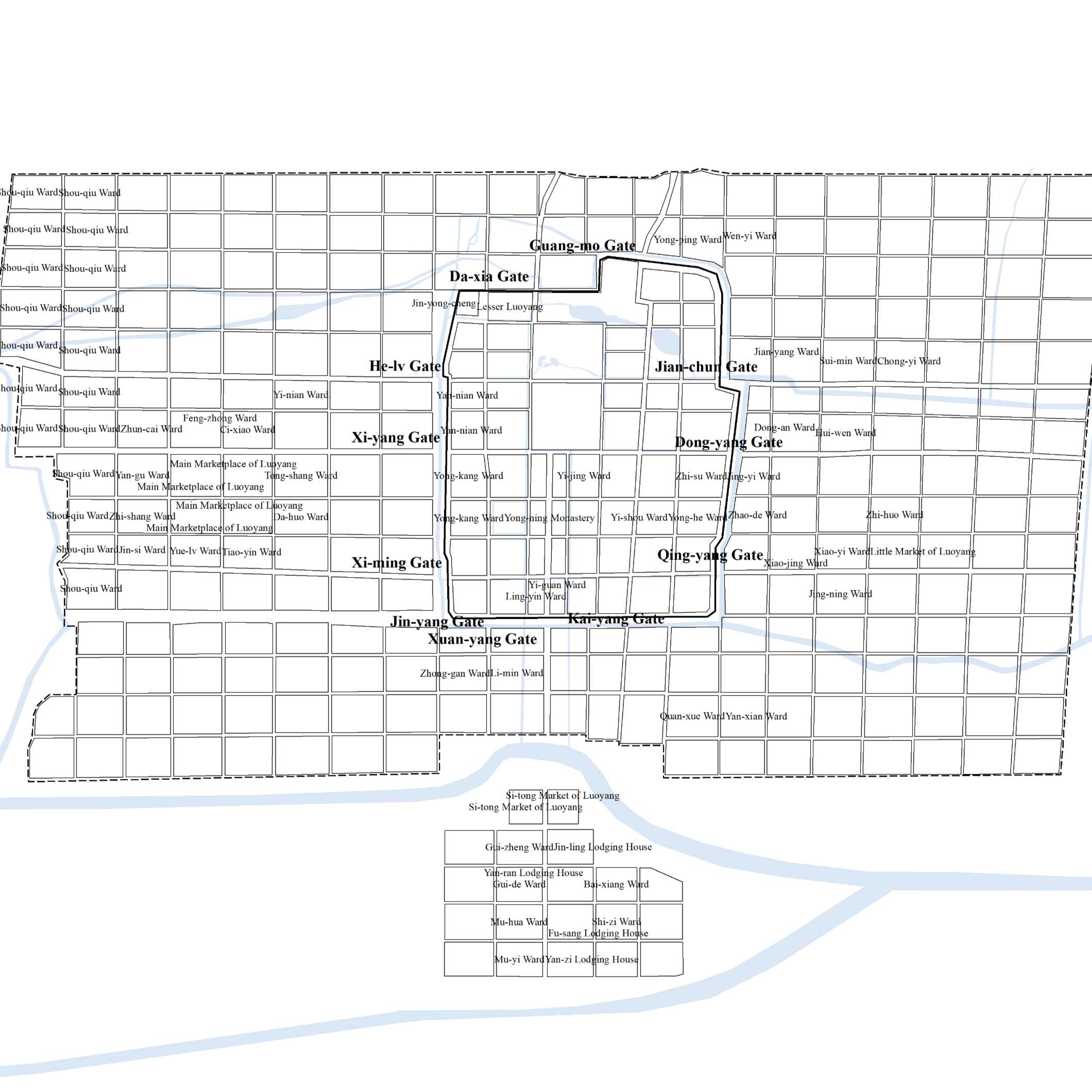
2.3Utilizing the information of Li Fang recorded in the book, combining with archaeological excavation and other data to recover the base map of Northern Wei Luoyang City
Functional Spaces
3.1 Spatialize functional spatial data and import into GIS to form shp filesS4_File. Functional space Data-Shp.zip53KB
3.2Kernel Density Analysis, Mean Centers, Standard Deviation Ellipses, etc. are performed, and the input parameters are described in detail at S5_File. Functional Space Input Parameter-GIS.xlsx9KB
3.3Formation of spatial analysis results and interpretation of the results
Event Spaces
4.1Using the locations where the starting and ending points of the events in the Luoyang Gazetteer are located as nodes, and the movement of the characters between locations as edges, the network information is filtered
4.2Importing information into Gephi to perform calculationsS7_File. Complex Network Files-Gephi.zip322KB
4.3Match the calculated information with the spatial information in a table and import it into GISS8_File. Complex Network Tables with Position Information-Gephi to GIS.zip9KB
4.4Make complex network diagrams with spatial information in GIS and interpret the results
Acknowledgements
The authors would like to express my sincere gratitude to Prof. Guoxiang Qian, Dr. Wei Zuo, Dr.
Yale Ye, Geng Pei and Zekai Li for their valuable support in software development
and literature search, which greatly contributed to the success of this work.