Jun 17, 2025
Protocols for Locality Data Collection, Area of Occupancy, and Extent of Occurence for IUCN Red List Assessment
- Nazifah Fitriyah Zariman1,
- Juliana Senawi1,2
- 1Department of Biological Sciences and Biotechnology, Faculty of Science and Technology, National University of Malaysia;
- 2Langkawi Research Centre, Tuanku Abdul Halim Mu’adzam Shah Campus, Universiti Kebangsaan Malaysia, Teluk Yu Road, Burau Bay, 07100, Langkawi, Malaysia


External link: https://doi.org/10.3897/BDJ.13.e162374
Protocol Citation: Nazifah Fitriyah Zariman, Juliana Senawi 2025. Protocols for Locality Data Collection, Area of Occupancy, and Extent of Occurence for IUCN Red List Assessment. protocols.io https://dx.doi.org/10.17504/protocols.io.q26g79kz8vwz/v1
Manuscript citation:
Zariman NF, Senawi J (2025) Species conservation profile and revision of Rhinolophusacuminatus (Chiroptera, Rhinolophidae) from Southeast Asia. Biodiversity Data Journal 13(). doi: 10.3897/BDJ.13.e162374
License: This is an open access protocol distributed under the terms of the Creative Commons Attribution License, which permits unrestricted use, distribution, and reproduction in any medium, provided the original author and source are credited
Protocol status: Working
We use this protocol and it's working
Created: May 15, 2025
Last Modified: June 17, 2025
Protocol Integer ID: 218307
Keywords: IUCN Red List Assessments, Chiroptera, Field work, Mapping, iucn red list assessment locality data, taxon through iucn red list criteria, iucn red list criteria, bat species, species identification, iucn eoo calculator toolbox, species, locality data collection, peninsular malaysia, number of location, taxon, area of occupancy, protocols for locality data collection, occupancy, satellite imagery
Abstract
Locality data for bat species in Peninsular Malaysia were obtained through literature review, field surveys, and museum records. Fieldwork involved harp traps, mist nets, and high nets, with biological measurements and species identification based on Kingston et al. (2006). Coordinates were standardized and mapped using QGIS 3.34.1. Area of Occupancy (AOO) and Extent of Occurrence (EOO) were calculated using GIS tools, including the IUCN EOO Calculator Toolbox in Arcmap 10.8.1. The number of locations was assessed using satellite imagery based on the most probable threat. This protocol is used for assessing the taxon through IUCN Red List criteria.
Guidelines
Harp traps were set up along forest trails, while mist nets and high nets were placed in open areas such as over rivers, within forest gaps, and in clearings at the study sites. All traps and nets were deployed from 7:00 PM to 7:00 AM, with a 20-metre distance maintained between harp traps. As the research involved wildlife, fieldwork protocols were strictly followed, including the use of face masks and gloves at all times.
Materials
Fieldwork and bat trapping were conducted using harp traps, mist nets, high nets, and GPS devices to record geographic coordinates. The Area of Occupancy (AOO) map was generated using QGIS, while the Extent of Occurrence (EOO) map was produced with ArcGIS incorporating the IUCN EOO Toolbox.
Safety warnings
Researchers were required to avoid disturbing natural habitats and to wear appropriate personal protective equipment (PPE) at all times during fieldwork. Rabies vaccination was also mandatory prior to engaging in any bat-handling activities.
Safety information
Rabies vaccination was also mandatory prior to engaging in any bat-handling activities.
Ethics statement
The protocol approval was received from the Institutional Animal Care and Use Committee at Texas Tech University (IACUC 10014-04; IACUC 18011-03). Permit to conduct research in Malaysia is received from Department of Wildlife and National Parks Peninsular Malaysia, the Forestry Department of Peninsular Malaysia, Sabah Biodiversity Centre, Sarawak Forestry Corporation, and the Malaysia Access to Biological Resources and Benefit Sharing (MyABS) under the code: (JPHL&TN (IP): 100-34/1.24 Jld 14(31); JPHL&TN (IP): 600-6/1/4 24 Jld 2 (117); EPU 40/200/19/3511(9); JH/100 Jld 22 (27); MBP.600(S)-1/1/1 Jld.4(10)).
Locality Data
Locality data was collected through a combination of literature review, fieldwork, and museum specimens.
Fieldwork was primarily conducted in Peninsular Malaysia, using bat trapping methods such as harp traps, mist nets, and high nets.
Harp traps were placed approximately 20 meters apart, while mist nets and high nets were set up in open spaces within the study area.
All traps and nets were deployed from dusk (1900 hrs) to dawn (0700 hrs), and their coordinates were recorded using a Garmin GPSMAP 65s device.
Measurements were taken for each captured individual, including forearm length, weight, sex, age, and reproductive status.
Species identification was performed using the taxonomic key provided by Kingston et al. (2006).
Museum data was obtained from the Zoological Museum of the Malaysian National University (UKM), where locality information for both skull and wet specimens of the species was recorded.
Distribution Map
All coordinates collected from literature reviews, fieldwork, and museum records were standardized and saved in decimal degree format.
The distribution map was created using QGIS version 3.34.1, with spatial data for each country sourced from GADM version 4.1 (2025).
All maps and coordinates were set to the WGS 1984 coordinate reference system (EPSG:4326).
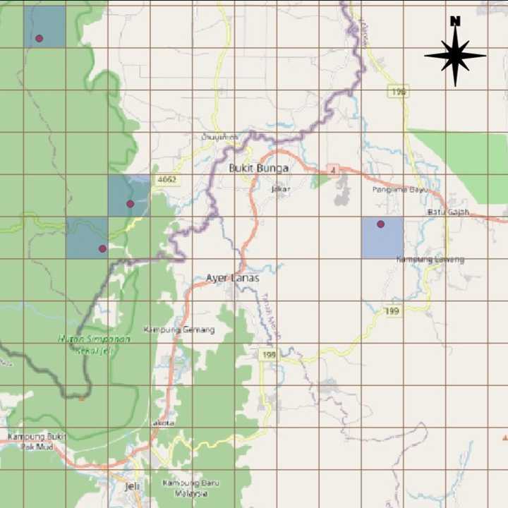
Area of Occupancy (AOO)
The Area of Occupancy (AOO) was calculated using the ‘grid’ tool in QGIS version 3.34.1 to create a 2 km x 2 km grid on the map.
Extent of Occurrence
The Extent of Occurrence (EOO) was calculated using the IUCN EOO Calculator Toolbox in ArcMap version 10.8.1 (Figure 2).
Before running the toolbox, presence, origin, and seasonal codes were assigned to each locality point.
Locations
Number of locations is determined by using ‘Google Satellite Image’ function in QGIS.
Choose the most probable threat for the species.
The number of locations is measured by introducing the threat to the localities.
Localities that are eliminated after introducing a single threatening event is considered as one location.
Protocol references
Kingston, T., Lim, BL. and Akbar, Z. 2009. Bats of Krau Wildlife Reserve. 2nd edition. Penerbit Universiti Kebangsaan Malaysia. Bangi.
IUCN Petitions and Standard Committee. 2022. Guidelines for Using the IUCN Red List Categories and Criteria. Version 15.1. Prepared by the Standards and Petitions Committee. https://www.iucnredlist.org/documents/RedListGuidelines.pdf.
Acknowledgements
This research was supported by the Ministry of Higher Education, Malaysia, through the Fundamental Research Grant Scheme (FRGS/1/2020/WAB11/UKM/02/3), the National Science Foundation, USA, via Texas Tech University (NSF-17-512; ST-2019-006), Lubee Bat Conservancy, and Universiti Kebangsaan Malaysia to J.S.; and by the Ministry of Higher Education, Malaysia, under the MyBrainSc Program (KPT(BS).1/23-990815145610) to N.F.Z.