Mar 17, 2026
Coastscape Engagement Index (CEI) Method
- 1Swedish Institute at Athens;
- 2National and Kapodistrian University of Athens
- CNuttall


Protocol Citation: Christopher Nuttall 2026. Coastscape Engagement Index (CEI) Method. protocols.io https://dx.doi.org/10.17504/protocols.io.q26g7on89vwz/v1
License: This is an open access protocol distributed under the terms of the Creative Commons Attribution License, which permits unrestricted use, distribution, and reproduction in any medium, provided the original author and source are credited
Protocol status: Working
We use this protocol and it's working.
Created: March 17, 2026
Last Modified: March 17, 2026
Protocol Integer ID: 313431
Keywords: Spatial analysis, GIS (Geographic Information Systems), Archaeological landscapes, Coastal archaeology, Maritime archaeology, Least Cost Path (LCP) analysis, Weighted regression model, Landscape Archaeology, Diachronic analysis, Settlement patterns, measure of coastscape engagement, method the coastscape engagement index, coastscape engagement index, diachronic patterns of coastal engagement, extent of coastal land use, coastal land use, coastscape engagement, coastal landscape, coastal proximity analysis, coastal proximity, coastal proximity value, coastal engagement, smaller coastal site, large coastal site, mixed system of smaller coastal site, coastline, experience of landscape navigation, land use, interaction with maritime environment, archaeological landscape, maritime environment, movement between archaeological site, coast, landscape navigation, insights into the spatial dynamic, natural environment, archaeological site, population of the region, interplay between human activity, spatial dynamic, spa
Funders Acknowledgements:
Swedish Research Council (Vetenskapsrådet)
Grant ID: Grant: 2022-06184
Disclaimer
Note: The Coastal Proximity Value (CPV) is obtained through Coastal Proximity Analysis (CPA), as described in the CPA Method document.
Abstract
The Coastscape Engagement Index (CEI) is a spatial analytical method designed to quantify the extent of coastal land use within archaeological landscapes. This index leverages the Coastal Proximity Value (CPV), derived from Coastal Proximity Analysis (CPA), to move beyond traditional Euclidean distance measures and consider the actual effort or ‘cost’ of movement between archaeological sites and the coastline. By employing a weighted regression model that assigns varying coefficients based on coastal proximity, the CEI provides a scaled measure of coastscape engagement that reflects the embodied experience of landscape navigation. This method is particularly useful for examining diachronic patterns of coastal engagement and identifying periods of increased or decreased interaction with maritime environments. The resulting CEI values offer insights into the spatial dynamics of coastal landscapes, highlighting the interplay between human activity, land use, and the natural environment. The purpose in basic terms is to determine where most of a region’s population is clustered in different time periods. For example, a large coastal site would mean that almost all of the population of the region live by the coast. In another example, a more mixed system of smaller coastal sites and upland sites would contribute less to the index as much of the population also lived further inland.
Guidelines
Note: it will only be possible to undertake this analysis if the area has been subject to extensive archaeological survey and site size data has been published.
Materials
- A PC or Laptop with Windows, Mac or Linux
- GIS software: QGIS recommended (3.3 and above). Download: [https://qgis.org/download/](https://qgis.org/download/)
- Coastal Proximity Values (CPV) for archaeological sites (obtained via Coastal Proximity Analysis, see CPA Method document: [https://dx.doi.org/10.17504/protocols.io.5jyl8x85dv2w/v1](https://dx.doi.org/10.17504/protocols.io.5jyl8x85dv2w/v1))
- Data: Land use areas for archaeological sites obtained from archaeological survey and a total coverage area for the landscape, in metres squared (m²).
Method Steps
2h 15m
For each archaeological site in each chronological period:
Determine the extent of land use (A) for each site in square meters.
Use the Coastal Proximity Value (CPV) in minutes from the Coastal Proximity Analysis (CPA) (see also: https://dx.doi.org/10.17504/protocols.io.5jyl8x85dv2w/v1) to determine the appropriate weight (χ) from Table 1 for each individual site.
Multiply the land use area of a site (A) by the weight (χ) to get the weighted land use area for each site.
| Band | Time cost (CPA Value) | M2 coefficient (%) | |
| 1 | 0 to 6 minutes | 100 | |
| 2 | 6 to 12 minutes | 90 | |
| 3 | 12 to 18 minutes | 80 | |
| 4 | 18 to 24 minutes | 70 | |
| 5 | 24 to 30 minutes | 60 | |
| 6 | 30 to 36 minutes | 50 | |
| 7 | 36 to 42 minutes | 40 | |
| 8 | 42 to 48 minutes | 30 | |
| 9 | 48 to 54 minutes | 20 | |
| 10 | 54 to 60 minutes | 10 | |
| 11 | 60+ minutes | 0 |
Table 1. Coastal Engagement Index (CEI) coefficient conversion. Note these coefficients can be modified to suit your own parameters.
1h
Sum the weighted land use (i.e. after the application of the regression weighting) areas for all sites within the same chronological period.
10m
Divide the sum by the total surface area of the landscape surveyed (B) to get the CEI value (C), using the formula:
CEI (C) = (Sum of (A * χ)) / B
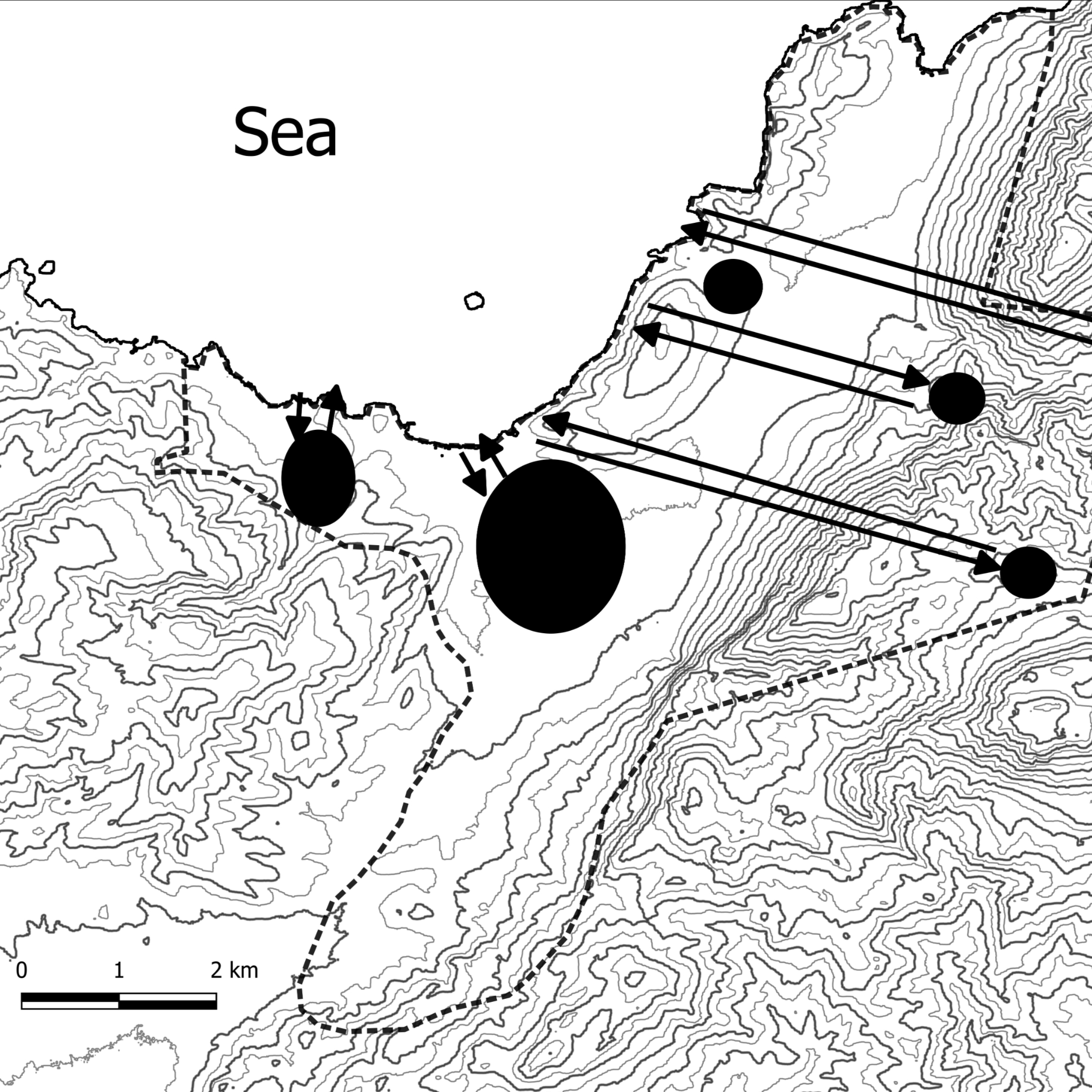
e.g. See Figure 1 for an example from Eastern Crete, Greece in the prehistoric period (Minoan). The Final Neolithic period has a total area coefficient of 16,990 m2 out of a total coverage area (indicated by the dotted line) of 45,000,000 m2. This gives a CEI value of 0.0004. For the Protopalatial period, the total area coefficient is 164,687 m2. This gives a CEI value of 0.0037, which means that the coastscape engagement is 9.25 times greater in the Protopalatial period than it is in the Final Neoltihic.
5m
Compare and contrast the value for different chronological periods to see the patterns in greater or lesser coastal engagement over time. The total value gives a comparative index as to the extent of coastscape engagement (See also Fig. 1).
Figure 1. Application of the method on archaeological sites from Eastern Crete, Greece. Note that the Protopalatial period stands out as the period with the highest engagement with the coast, though generally between the Early Prepalatial and the Neopalatial period, the engagement level is high. Final Neolithic and Final Palatial periods stand out as those with much less coastscape engagement.
1h
Protocol references
Nuttall, C. 2024. “A GIS Analysis of Coastal Proximity with a Prehistoric Greek Case Study.” JCAA, Journal of Computer Applications in Archaeology, Vol. 7, Issue 1, pp. 170–184. https://doi.org/10.5334/jcaa.143
Nuttall, C. In review. “Spatial analytical approaches to Minoan coastscapes: A long-term perspective.” In
Spatial approaches to Ancient Greek landscapes, edited by C. Nuttall, Acta-Ath8, Swedish Institute at Athens.